
Plans were finalized for our two-day trip to Capitol Reef National Park. To make it special, our son booked a camping site on the Fruita Camping ground there and all of us, especially our grand kids were excited. Our trip was scheduled for July end, when the maximum temperature hovers around 32.4 degree C and the minimum, 15.2 C. It was going to be pretty hot, no doubt, but we had no choice.
Capitol Reef National Park is in south-central Utah. The park was named for a line of white domes and cliffs of Navajo Sandstone,
 each of which looks somewhat like the United States Capitol building. The park is approximately 97 km long on its north–south axis and just 9.7 km wide on average.
 Established in 1971 to preserve 978.95 sq km of desert landscape, the park is filled with brilliantly colored sandstone cliffs, gleaming white domes, and contrasting layers of orange stone and earth, standing majestic against the backdrop of the azure sky. The Park is open all year, May through September witnessing the maximum visitors.


We started our drive from Salt Lake City as early as we could and reached Capitol Reef after a 4 hour drive, around 11.30 am. We halted at Torrey, a small town, the closest to the park an armed ourselves with crates of bottled water, and firewood.

 As we were approaching the park, we saw the reddish orange and white rocks resplendent against the blue sky.


The park has one developed campground that requires reservations from March to October, and two free primitive camping areas. We had already booked a camping lot online at Fruita camping grounds, and got our reservation number .
The campground, made up of 71 campsites, is the primary location for camping. There are restrooms onsite but these do not contain showers. We drove to our particular camping lot, and found that it had our name displayed on it.
This camping ground, located in the Fruita orchard, is full of fruit trees - cherries, apricots, apples, peaches .... planted by Mormon pioneers and maintained by the National Park Service, which can be harvested by visitors for a fee.

It was the apricot season and the trees nearby were loaded with them, even as the place was permeated by its aroma.

The kids (well, even we elders) couldn't resist the temptation of strolling across to the apricot-laden trees to try out a few fresh, crisp ones straight from the tree - even though we were not great fans of that fruit. We would have loved peaches or apples more.
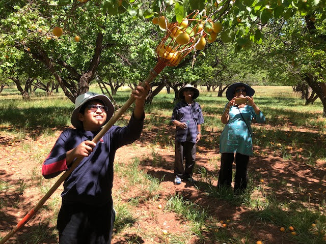
There were poles with net-sacks attached to them for kids to enjoy the thrill of plucking the fruits.

We did have a blast, to say the least.
We then unloaded our lunch basket ....

but all of us had a frugal lunch as we were full with the apricots.

It was time to explore the park. We first drove to the Visitor Center - it had good restrooms and also water-stations where we could fill up our bottles with drinking water. That was cool - we made sure not to dispose of any of the empty little water bottles but use them to refill. Shops were a long drive from the camping grounds, you see. We also picked up a brochure from the Visitor Center.
We decided to drive along the scenic drive which promised visitors some highlights, but we soon discovered it runs only a few miles from the main highway and our car could not go too far - the road was unpaved, and the sign board cautioned us that it was not wise to drive farther. But hiking in the hot sun, with kids and oldies in tow was not an option.

So our son chose to take a chance and drove on - carefully, slowly ... and we soon discovered we were not the only ones.


Our family was back in about 40 minutes - it was scary to watch them gingerly climb down the rocks and slippery sand.


Oh weren't we relieved at the end of the trek to hop back in the car and get the AC working ... We had spent more than two hours there - during the hottest part of the day - couldn't help it.


Mormons had settled in the Fremont River valley in the 1880's had established Junction (later renamed Fruita), and Caineville, and Aldridge. Only Fruita prospered. In addition to farming, lime was extracted from local limestone, and uranium was extracted early in the 20th century. By 1920 no more than ten families at one time were sustained by the fertile flood plain of the Fremont River.
We drove past the small one-room Fruita School house which had earlier catered to the kids of the community.
Like everyone else, we too drove to Clifford House - a modest building - for the famous home-made pies and goodies for tea time.
We were happy to drive back to our campground for the next eagerly awaited, exciting task - putting up our tent before dusk.


Next we were ready for our tea, while the kids were waiting eagerly for s'mores! A s'more is a campfire-treat popular in the United States, Mexico, and Canada, consisting of a roasted marshmallow and a layer of chocolate placed between two pieces of graham cracker or cookie. All the ingredients were ready with us; also skewer sticks for roasting the marshmallows.
 The first step was lighting our campfire. The firewood we had bought on our way, was unloaded. The fire was lit successfully. My daughter-in-law started heating water in the large vessel we had tugged along. When the water started boiling, the kids got their cups of hot chocolate. Then our tea was brewing as everyone stood around excited. The kids waited patiently till everyone finished tea.

Next came the much-awaited highlight of the evening - roasting marshmallows for s'mores.
 Everyone relished them, with the chocolate and marshmallows melting in their mouths. This went on till the fire died out. In fact, campers can leave their sites only after their campfire is fully extinguished. Rangers are found riding around to keep a watch / to offer assistance.

As the kids went for a stroll, I scrutinized the brochure of the park. The entrance fee is $20.00 for private vehicles and $10.00 for pedestrians.
Capitol Reef is open year-round and hosts a variety of different activities, both ranger-led and self-guided. There are many different options for ways to spend your time, based on the number of days or hours you intend to stay, from picking fruits in the orchards to hiking and backpacking trips.
The following trails seemed popular -
Frying Pan Trail - 4.41 miles one way, taking hikers through multiple sights, including the Cassidy Arch, Grand Wash, and Cohab Canyon had to be ruled out as it was too strenuous.
Brimhall Natural Bridge is 4.46 miles round-trip, popular but strenuous again.
Cassidy Arch Trail is a 3.5 round-trip mile trail, leading hikers into the Grand Wash and providing an overlook of the Cassidy Arch. This hike is very steep and hence rather strenuous.
Hickman Bridge Trail, "one of the better known sites of Capitol Reef", is easier than the Cassidy Arch - the trail is only 2 miles round trip and provides views of the natural bridge.
Well, with just the next half a day at our disposal at the Park, we had to choose wisely, so it was going to be just the Hickman Trail Bridge the next day.
We chilled for a while, looking around at the other campers - our neighbors seemed to be seasoned campers - they had come armed with gadgets of all sorts .... and .... we had considered ourselves the smart campers.


We drove to the spot - it was pitch dark. No street lights. A few cars were parked there, headlights turned off to maintain total darkness. Absolutely no lights - just the light from the mobile phones. Absolute silence - everyone was talking in hushed tones - never experienced such ultimate calm and silence anywhere.
One look at the sky and we went, "WOW".... Against the dark blue sky, dazzled millions of stars ..... we tried to click pictures but couldn't manage to, due to the darkness. As we kept staring at the glittering galaxy in awe, my daughter-in-law called each of us and in hushed tones, pointed to the various planets and stars on her iPhone with a special app she had just downloaded. That was really cool - she pointed her phone to a bright constellation and its name showed up on the screen - Jupiter, Saturn, Mars .....! The kids were overjoyed and went on repeatedly looking at the various constellations. We spent half an hour there, enjoying the magnificence of the spectacle. Truly this had to be the USP of the trip.
We drove back to our campsite, used the restroom, removed our footwear, crawled inside the tent, and took our positions on the beds. The kids were soon fast asleep, we elders slept in spurts ..... and .... before we realized it, it was dawn.
After the morning rituals, (no shower, as I told you), we changed our outfits and got ready for the day.

When we were back, the family was up and was getting ready for the day.
We had sandwiches, fruits and juice for breakfast, then cleared the table, repacked our tent and quilts, loaded the car, and were ready to set off for the day's sight-seeing.
We bid adieu to our home for a night and drove on before 10.


As we trudged back, we were hot and tired.


Once again we made a stopover at Clifford House for the famed pie, as well as coffee and ice cream before we started our drive back home in Salt Lake City.

After our return, I was motivated to write a blog post on all the five national parks of Utah, which we have visited.
ZION NATIONAL PARK
ZION NATIONAL PARK
I have to take you next to Zion National Park, which we had first visited in April 2004, and revisited in July 2015.
During the first visit, we had camped for a night in Zion's, with my son and daughter-in-law. The 2015 visit was with our little grand kids too and we spent two days going around Zion's, spending the night in a nice 3-bedroom apartment outside Park.
Zion National Park is located in southwestern Utah near the town of Springdale.
The 593 square-km Zion Canyon National Park is 24 km long and up to 805 m deep. The canyon walls are reddish and tan-colored Navajo Sandstone eroded by the North Fork of the Virgin River. The lowest point in the park is 1,117 m at Coalpits Wash and the highest peak is 2,660 m at Horse Ranch Mountain. The park has a unique geography and a variety of life zones that allow for unusual plant and animal diversity. Zion National Park includes mountains, canyons, buttes, mesas, monoliths, rivers, slot canyons, and natural arches.
Seven trails with round-trip times of half an hour (Weeping Rock) to 4 hours (Angels Landing) are found in Zion Canyon. Hiking up into The Narrows from the Temple of Sinawava is popular in summer.
During our 2004 visit, both of us went with our newly married son and daughter-in-law. We had planned to camp for a night in Zion but not made any reservation. So at the end of the 4 1/2 hour drive from Salt Lake City, we went straight to the camping ground, where the signs said all parking lots and camping lots were full. However, the Ranger there told us to rush to find a slot. My daughter-in-law picked up a form for the camping site and started filling out the details, while we were all eyes to locate any vacant spot as my son drove around slowly. We were lucky to find a good one - site no. 73, close to a creek, with an adjacent car park. The form was duly filled, the charges - 16 $ cash was also enclosed in the same envelope, which was then sealed and dropped in the box at the Registration office. No online bookings in those days.

We brought out our home-made lunch of idlis, tamarind rice, curd rice and Pringles and fruits. Then we cleared the trash and left for sight-seeing around 2.30 pm.
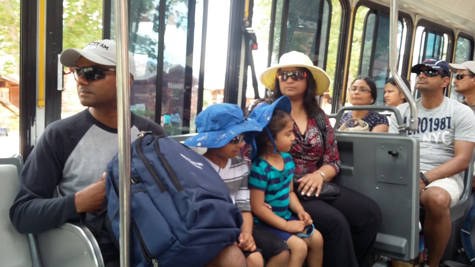
After the mandatory visit to the Visitor Center, we took the Shuttle (cars are allowed only from Oct to Feb). Our first halt was the Museum - we saw the 22 minute film on Zion.


We visited a restaurant for coffee, bought some snacks and returned to the camping site.
It was 6.30 pm and it was time to get our tent ready for the night when there was still daylight. We spread the rugs, sleeping bags and blankets inside and put away our snacks, water/juice bottles, flashlight, poker stuff ... all in specific pockets of the tent to be used at night.
We again lit up the bonfire, which helped to warm us up, even as were shivering despite our sweater and jacket. Then 'dry' dinner, poker game till 11, then the mandatory restroom visit and then to bed.
This was our first camping experience and hence very thrilling. We woke up the next morning and wound up exactly as described earlier, packed up, and left Zion's around 10 am.

Well, we made up for the short visit to Zion by visiting it again after more than a decade. This time it was a two-day trip, with one night's halt in a resort a few miles from Zion.

We had decided on the trails we wanted to take up that day,
 took the shuttle and hopped on and off at various points and took the trails,
 walking at our own pace with the little kids who grabbed every opportunity to take a break.
 A fact-seeking /entertainment break,


We then drove to our resort and got our rest.


The highlight of the day was the walk to the Narrows. We had come equipped with water shoes, and we had fun taking up the strenuous trail.


The two trips brought in a sense of fulfillment to our Zion National Park experience.
BRYCE CANYON NATIONAL PARK
BRYCE CANYON NATIONAL PARK
It was during our first trip to Zion that we drove to Bryce Canyon National Park, also located in southwest Utah, just 50 miles northeast of Zion National Park. Bryce Canyon National Park is much smaller, and sits at a much higher elevation (610 m) than the nearby Zion National Park. So the weather in Bryce Canyon is cooler (temperature was around 5 deg C in April). Bryce covers 145 sq km and receives substantially fewer visitors than Zion National Park or Grand Canyon National Park, largely due to its more remote location.
There are two campgrounds in the park, Loop A in North Campground (open all year round) and Sunset Campground (open from late spring to early autumn). The 114-room Bryce Canyon Lodge is another way to stay overnight in the park. But we had no plans of staying overnight there.
When we had visited way back in 2004, the entry fee for the park was 20$. As shuttles start operation only in May, we could drive around in our car and it suited us fine.


Unlike in the other National Parks, there are not too many long trails - just short easier walks from our car.


It was cold and windy, and sunny as well.
We had planned to skip the next Point - Inspiration Point but as per our guide map, it had the best views.
 So we did make a halt there too.
 We were glad we did not miss it - it provided such stunning views. (Sorry, the photo's colors have faded over the years).


After that we headed to Paria View to get a view of the Southern side as well - it had white limestone too. But it was a letdown after Inspiration Point.
Rainbow Point, the highest part of the park at 2775 m, Yellow Creek is the lowest part of the park at 2018 m.
We had to be content with just half a day there - we started our drive back to Salt Lake City and were happy to be home in four hours.
ARCHES NATIONAL PARK
During our visit to Salt Lake City in 2006, we undertook a trip to Arches National Park and Canyonlands National Park in eastern Utah. Our visit was in July, when the maximum temperature was 36 and the minimum 19 degree C.
The parks are adjacent to the Colorado River, 4 miles north of Moab, Utah. Before proceeding to Arches, we went in for a seven-mile river rafting on the rapids of Moab river (yet another thrilling experience), which lasted for two hours.
It is said that Arches National park contains the highest density of natural arches in the world - more than 2,000 natural sandstone arches.
It is said that Arches National park contains the highest density of natural arches in the world - more than 2,000 natural sandstone arches.

We decided to climb up to it that evening. It was going to be a tough, steep climb and we had braced ourselves for the herculean task. We reached the base of the trail at 6.30 pm and started off, armed with drinks and snacks. We were informed that sunset was at 8.10 pm.
The climb was safe but strenuous - we were panting for breath and took intermittent two-minute breaks and two sips of drinks after every steep climb. There was no sign of the arch even after climbing halfway which made us wonder how far it could be!
 We persisted with dogged determination, inching our way ...... till the arch appeared all of a sudden as we went around a corner. Oh, what a relief to realize we were right there - in just an hour!
The climb was safe but strenuous - we were panting for breath and took intermittent two-minute breaks and two sips of drinks after every steep climb. There was no sign of the arch even after climbing halfway which made us wonder how far it could be!


Those were the days of cameras - I had a camera with a film roll, so my photos were restricted in number. My son had a digital camera and so there were more pics from his side.

We energized ourselves with snacks and drinks and started our climb down at 8 pm. That was of course easier and faster and we reached the base in 40 minutes. We were mighty thrilled with our achievement. But then we also decided to pamper our poor feet by dipping them in the warm pool of our hotel before going for a hot shower before hitting the bed.
 The next morning, we again drove to Arches - first to the Visitor Center, which we couldn't visit the previous day.
Then we drove past Three Gossips, Sheep Rock, the enormous Tower of Babel, Petrified Dunes, and parade of Elephants ....
 and Balanced Rock, located at about 9 miles from the park entrance, which is one of the most popular features of Arches National Park. In an hour, we reached the trail of North and South Windows and
 Turret Arch. We completed the trail of one-mile-loop in 45 minutes - the Windows were nice but the Turret was more impressive - we climbed right up the Turret and saw the Windows from there.
Then we drove through Panorama Point and then to Delicate Arch Point from where we got a distant view of the Delicate Arch. Definitely our grueling climb the previous day was worth the effort - otherwise we would have missed the majestic view.
We continued to drive through Fiery Furnace Viewpoint to Devil's Garden Trailhead.
 We walked up to Landscape Arch (1.6 miles) but skipped the Double O Arch (4.2 miles with difficult elevation). Even that was difficult and exhausting due to the oppressive heat and hard-to-find shade of shrubs and trees but it was a bit of a let-down, so we decided against getting close to it.
 We also got close to Petrified Dunes.
After the 50 minute trek, we were ready for lunch at Subway.

Then we drove past Three Gossips, Sheep Rock, the enormous Tower of Babel, Petrified Dunes, and parade of Elephants ....


Then we drove through Panorama Point and then to Delicate Arch Point from where we got a distant view of the Delicate Arch. Definitely our grueling climb the previous day was worth the effort - otherwise we would have missed the majestic view.
We continued to drive through Fiery Furnace Viewpoint to Devil's Garden Trailhead.


After the 50 minute trek, we were ready for lunch at Subway.
CANYONLANDS NATIONAL PARK
We reached Canyonlands National Park in forty minutes. Carved by the Colorado River, this park - 'heart of the high desert' - offers visitors hiking, star-gazing, camping, and technical rock climbing. Established in 1964, the park preserves 527 square miles of colorful landscape that has eroded into countless canyons, mesas, arches, and buttes by the Colorado River and its tributaries. Canyonlands National Park, offers you a clear view of the night sky in its full splendor due to low light pollution and excellent air quality. But we could not include it in our list of activities as we had to drive back home after just a couple of hours in Canyonlands.
Established in 1964, the park preserves 527 square miles of colorful landscape that has eroded into countless canyons, mesas, arches, and buttes by the Colorado River and its tributaries. The Colorado and Green rivers divide the park into four districts: Island in the Sky, the Needles, the Maze, and the rivers themselves. While these areas share a primitive desert atmosphere, each retains its own character and offers different opportunities for exploration. The desert looked sparse, but it is said that most of Canyonland’s wildlife has adapted to hot daytime temperatures. The weather and seasons play a big role in determining what animals are active, and most of the park’s wildlife is nocturnal. Rock squirrels, chipmunks, lizards, snakes, and eagles are all primarily active during the day.
We drove past Shafer Canyon, Neck Spring and Buck Canyon (which resembled a mini Grand Canyon) and then Orange Cliffs (reminding us of a less intricate Bryce Canyon) and reached Grand View Point Overlook from where we could barely see the confluence of Colorado with Green River.
 After that it was time for the multi-colored Mesa Arch, the highlight of this Park. We took the 30-minute loop trail - it was not very tedious and we enjoyed the fabulous sight.
We started our drive back to Salt Lake City after 3 pm and reached home after 4 1/2 hours.
*********************************************************
All these National Parks in Utah, USA, instill a sense of awe with their majestic looks; their maintenance and provision of amenities invite tourists in large numbers. We consider ourselves lucky to have had the opportunity to visit these five National Parks.
We drove past Shafer Canyon, Neck Spring and Buck Canyon (which resembled a mini Grand Canyon) and then Orange Cliffs (reminding us of a less intricate Bryce Canyon) and reached Grand View Point Overlook from where we could barely see the confluence of Colorado with Green River.

We started our drive back to Salt Lake City after 3 pm and reached home after 4 1/2 hours.
*********************************************************
All these National Parks in Utah, USA, instill a sense of awe with their majestic looks; their maintenance and provision of amenities invite tourists in large numbers. We consider ourselves lucky to have had the opportunity to visit these five National Parks.
No comments:
Post a Comment